

Msida Creek
A crucial intersection.
Msida Creek is a crucial intersection, linking some of Malta’s main and most populated localities within short distances. Hence, the delivery and effectiveness of this project must be nothing short of perfection. Traffic accidents in Malta have reached record levels this year. Sustainable and active mobility is becoming ever so important but also more difficult, especially when new projects put the car first. While we still need to account for the great number of cars on the island, we need to shift our perspective and put pedestrians, bicycle users and bus users first. These modes of transport are more efficient, take up less space, and positively impact the environment and our health. We refer to the aphorism, “if you find yourself in a hole, stop digging”. We design roads for cars, then we ask ourselves why don’t more people walk or cycle? The answer is right before our eyes, we just need to see it.
Rota finds the new changes significantly improved over the previous design for Msida Creek, but we stress for more improvement. While it is an improvement over the previous design, we find the improvement over the current state of Msida Creek to not be adequate for bicycle users. Two primary concerns include missing essential links between localities and the lack of bicycle lanes. Msida creek is a crucial intersection which connects several key localities. Therefore, we must prioritise the plan for an eventual bicycle network around Malta with immediate effect and include bicycle lanes in such high-speed zones. We also highlight that space is available for such interventions.
As part of our consultation, we visited the Msida junction over 3 different days of the week. We noticed that this is frequented by hundreds of pedestrians over the span of an hour, which reinforces our plea to truly prioritise pedestrians and cyclists in this project.
Guiding Principles
As a preamble, we must refer to the 5 CROW guiding principles which are crucial for pedestrians and bicycle users. Every intersection needs to consider these 5 principles, or else it will fail the users. If we were to assess this for car users, we find that most of the new projects implemented over the past years check most of these points for CAR users, but leave much to be desired for pedestrians and bicycle users. We need to start prioritising these principles for active mobility. The dangers in our roads are real, and it is our responsibility to voice the concerns of many bicycle users, including our own.
- Cohesion – Connecting origins and destinations
- Directness – Creating short and fast routes, while minimising detours
- Safety – Avoid differences in speed and mass of vehicles
- Comfort – Minimal stops or nuisances
- Attractiveness – The only subjective point here
Unless otherwise specified, the term users in this webpage refers to pedestrians and bicycle users.
In depth feedback on current plans
Published on 13 of November 2022
Scroll below to read our preliminary feedback.
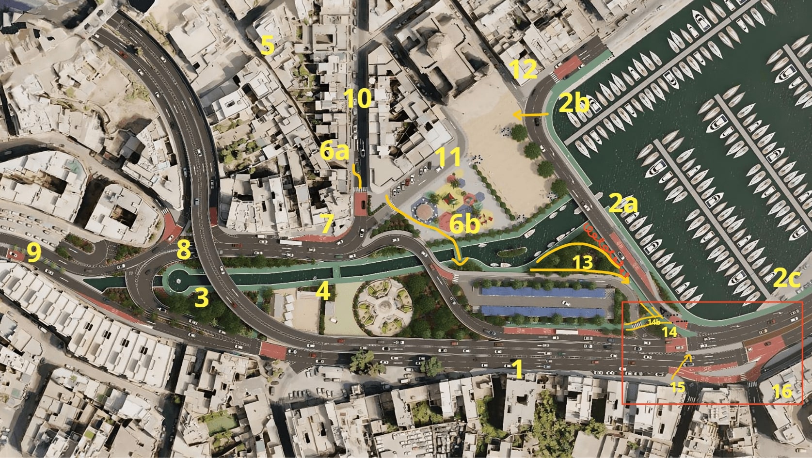
We will be referring to this image as a reference since this includes labels which will enable us to pinpoint problematic areas.
Below is a reimagined plan for the Msida Creek Project, which is based on and mostly still retains Infrastructure Malta’s latest published plans. The architects who designed this for us, did so voluntarily, and aimed to show how the huge space of the junction can cater for the bicycle path while keeping the flyover and most of the car lanes. This is by no means a precise plan as it is not our duty to design roads ourselves, but we felt the need to provide this indicative plan to show the minimum bicycle infrastructure needed for Msida, a crucial junction to link a bicycle network with the surrounding nearby towns. St Julian’s and Paceville are just 3km north, and Marsa just 2km in the other direction linking to the south of Malta. The main feature of the bicycle infrastructure is a two-way path that goes round the entire junction like a ring, between 2.8-3m wide, connecting all the side streets feeding to the junction and the amenities on the way.
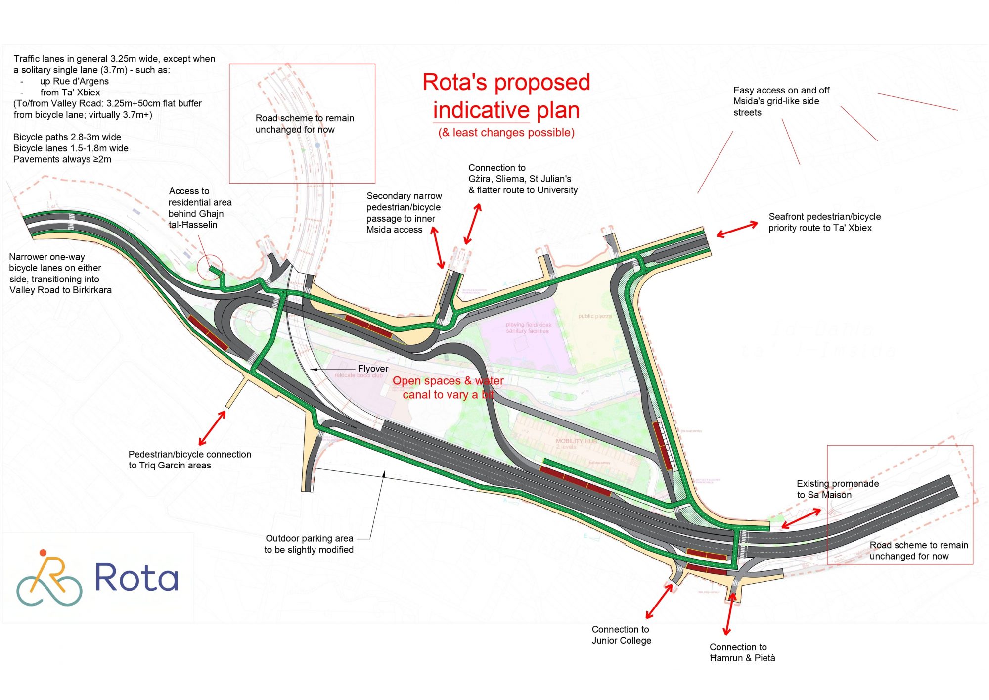
Download hi-res render here: Msida Creek Reimagined Plans
Point 1 – Need for direct and safe bicycle passage
In our meeting with IM, it was highlighted that cyclists can use the pavement, and IM also noted that this has a pinch point of 1.5m. In a 5 car lane street this is unacceptable. The bicycle should not be forced to use pavement to avoid dangerous encounters with cars, unless the pavement is specifically designed for bicycle use. This is one of the most crucial changes that is needed in this project. There are 5 car lanes in the design. If we shave off 20cm from each, we can win a 1 metre bicycle lane. The wider the better since if we can gain more width we can have the lane segregated. We also highlight that the car lanes do not have to be the same width all the way. It is important to note that research shows that speeding increases with increasing lane widths. Space is not an issue here, it is a matter of prioritisation. Do we want bicycle users to have safe and direct access?
Point 2 – Revamp of the bridge design
This is one of the most important crossings in the project, since it is connecting Msida to Gzira and Ta’ Xbiex, and vice versa. These are our suggestions:
- The Green path by the sea at 2A can be eliminated. Instead of this, we should segregate users to another bridge right next to the one for cars. This can be the same bridge, as long as different traffic is segregated completely, and the surface used is different. If we opt for the latter, the current bridge design will need to be widened to allow for more comfortable shared space. However, we recommend having a separate bridge since this is safer. We make reference to the pedestrian bridge near AUM in Birgu. Such a design for users will be the ideal option. This will allow more directness for pedestrians and bicycle traffic, and more comfort since it is elevated and will also be more difficult to flood when it rains.
- The adoption of the previous point will allow the removal of the green path underneath the bridge, which is prone to flooding and is not direct. This path also contains blind corners (90 degree corners) which poses a risk for users, since you never know if a bicycle is approaching. Research also shows that such scenarios are especially scary for female users, so we should avoid such corners. The route should be visible at all times. We have also seen the problem in the Msida skatepark subway (after which mirrors were retrofitted).
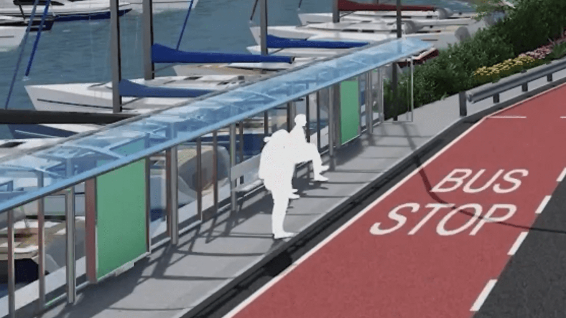
- After the Zebra crossing at 2B (going towards 2A), the car lanes should be one lane since it closes up to one lane anyway at the end of the bridge. This will allow more space for the pedestrian bridge.
- The bus stop on the bridge can remain as is, or else shifted to 2B.
These changes will improve this point of the design drastically. While the passage by the sea looks superb on paper, having a pedestrian bridge is a much better option and is liked more by users.
Point 3 – Concerns on the inlet
While the pedestrian path extends up to here, we have some concerns over the water quality here. Will there be a pump to move the water? If not, a number of people have voiced concerns over the smell and quality of the sea water that will collect here. They have also raised concerns over the fact that any waste carried by rainwater will be deposited here. A suggestion we’ve received is to collect rainwater in reservoirs rather than throw it out to sea, which will in turn be used to water all the plants and trees in the area. While this is not directly a topic of our concern, if the stagnant water leads to bad smell and mosquitoes, this will impact the experience (CROW Attractiveness principle) of users.
Point 4 – Crossing to Point 7
A crossing from Point 7 to Point 4 will be ideal for users to provide more directness.
Point 5 – Alternative Route to University
In our last meeting, IM suggested a route to University through this area. We reiterate that if alternative routes are suggested, signage is included from before and throughout the route to make sure it is easily accessible by users. Another alternative route to University (but lengthier, thus going against the CROW principle of directness) is: https://goo.gl/maps/fL24YqqxuU178BYw5. However, the most direct, obvious and cohesive route is from the bypass at point 8. There is ample space right now for a bicycle lane on both sides of the roads.
Point 6 – Extend pavement and connect 6b
We’ve illustrated at point 6A that the pavement should be extended (marked with orange) so users coming from Point 5 have ample space to turn and reach the zebra crossing at 6a. The route should connect well to the bridge at point 6B. In the proposed plans, the orange arrow at 6b is not possible, but with this small intervention it can be made more accessible.
Point 7 – Extend pavement
The pavement here can be extended further rather than having the extra hard shoulder for the bus lanes (which is illustrated as a very narrow red area). On the plans this is marked as an unloading bay area, can you confirm if this will remain as a bus stop please? This area also needs to be connected to point 4 as explained previously.
Point 8 – Safe crossing
This is another ideal location to introduce a crossing to enter the green pathway for users coming from the other side of the road.
Point 9 – Bicycle lanes
If this area is within the project’s scope, can space be rearranged here to make room for safe bicycle access?
Point 10 – Traffic calming measures and a bicycle lane
This road is currently used as a very wide single car lane with parking on the side. We note that this can be improved for users by extending the pavements and installing a bicycle lane and slow traffic.
Point 11 – Pedestrian areas
We took note of this point to confirm if the muted gray areas make use of cobblestones since these are a good way of slowing down traffic.
Point 12 – Bicycle Racks
This is an ideal location for bicycle racks.
Point 13 – Redesign of access
For this point, we propose that trees are shifted towards the bridge (marked in red) so users can have direct access along the path (marked with an orange arrow). The orange line also shows a curved path which can be used as an alternative, which also avoids having a blind corner. This makes this portion of the project more user-friendly.
Point 14 – Redesign of junction
The current design includes a 90 degree turn (14B) for users, which is not comfortable for bicycle users, especially with oncoming foot or bicycle traffic. Hence, we suggest a small intervention which straightens the path, extending it as a slanted crossing to the other side (illustrated in black dots). This improved the overall experience of all users making use of this junction.
Point 15 and 16 – Crossing needed
A crossing at point 15 would offer the most direct crossing, given the current design. One note on this, which we will delve deeper in the following feedback, is that the currently existent crossings from the side of Junior College to the marina will not improve at all with the newly proposed project. As commented in the beginning, area 16 (marked with a red bordered box) is frequented by thousands of users on a daily basis. What can be done to improve the experience of users at these crossings? How can we make the crossing more direct and comfortable for users?
![]() Download PDF version of In-depth feedback
Download PDF version of In-depth feedback
Preliminary feedback
This preliminary feedback was published on the 24th of October 2022
Positive changes from previous Infrastructure Malta plans
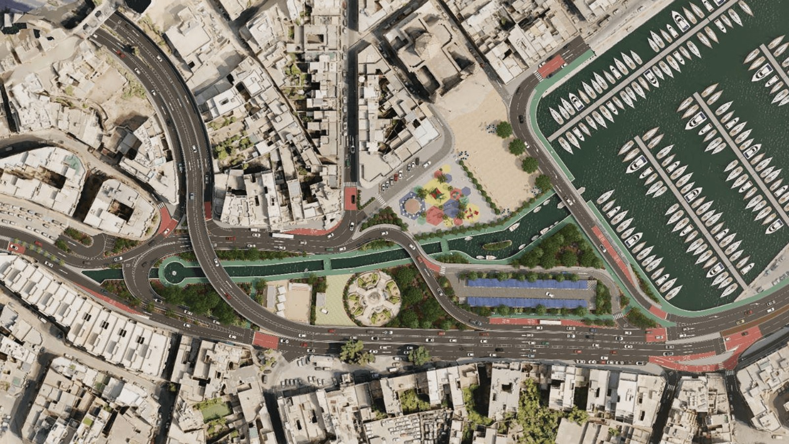
The removal of pedestrian bridges
One notable change for pedestrians and bicycle users is the removal of pedestrian bridges in favour of on-grade crossings. We highlight that this is not an improvement over the current state of Msida Creek, but an improvement over the previous proposed design for the area. Moving away from designing more pedestrian bridges has been a step in the right direction. These bridges, while seemingly safe and convenient, are actually frustrating for pedestrians and bicycle users since they add time, distance and effort to cross the road. Additionally, as we have seen in cases such as Marsa, where the only crossing depends on lifts, pedestrians and bicycle users end up being isolated when these malfunction (which is a very common occurrence based on the data we collect from www.rota.mt/lifts). This improvement creates much better and reliable street-level pedestrian and cycling crossings. We highlight that on-grade crossings must be designed with the user in mind and should not come with long waiting times for pelican crossings, and the crossing should be well visible for oncoming traffic. Additionally, such crossings should be as direct as possible to make crossing efficient. Traffic calming measures approaching crossings prove to make them safer as well.
Open space
The green area is also a step in the right direction since this creates a safe buffer zone between areas. We also commend the redesign of the village piazza, which stops traffic flow and creates an open space for people. Prioritising open spaces in a busy intersection is a step in the right direction, since we are lacking such spaces in Malta.
Improvements Needed
This section will recommend in more detail how the 2 main problems highlighted below can be addressed.
- Missing essential connections between localities
- The lack of bicycle lanes in a high speed zone. We strongly recommend the introduction of bicycle lanes on both sides, especially in the direction towards Birkirkara since bicycle users will be cycling next to 5 car lanes.
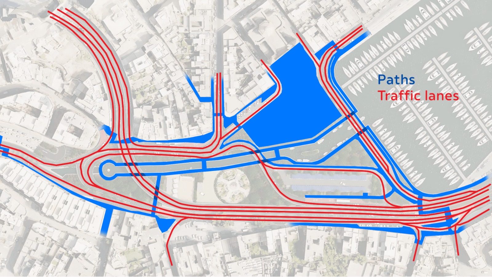
Widths of shared paths
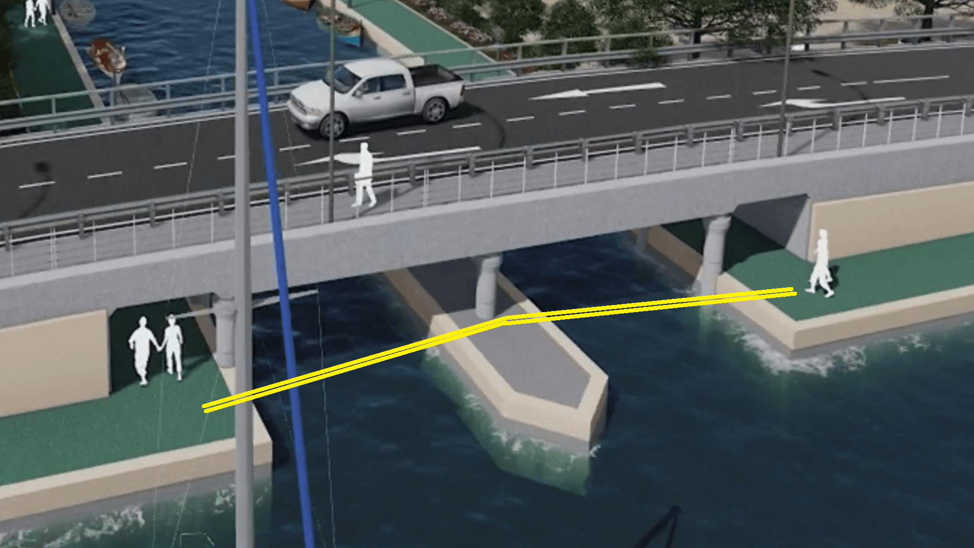
While we do not have the exact measurements of the paths visualised in the design, we can assume from the proportions. The adjacent lowered green path, mainly for scenic/recreational use has several tight turns which can be problematic by bicycles, especially longer ones such as tandems, cargo bikes, or having an attached trailer. It might also pose to be the most flooded section of the road as well when it rains, as it is lower than the main carriageway. Squeezing several users together into small spaces can lead to conflict, accidents and annoying situations of inefficiency.
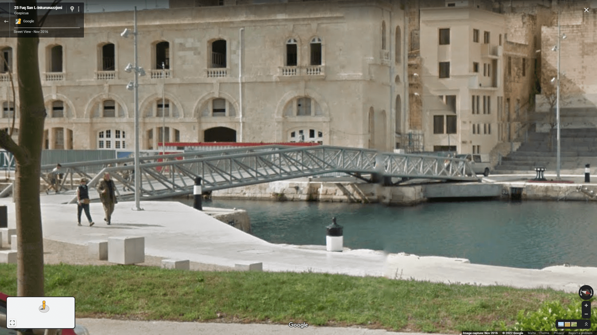
One alternative to the crossing highlighted in yellow in the image below would be to have a bridge wide enough for cyclists and pedestrians directly and without any diversions, similar to the recently built pedestrian bridge in Bormla Dock 1, where small boats can still traverse beneath. Otherwise the bridge in the design should be extended to allow ample space for pedestrians and cyclists to share the space.
Circular Bicycle Path
The project scheme requires a circular two-way bike path that covers the perimeter of the entire Msida Creek junction, which can connect buildings and establishments along the way. This is a major intervention on the proposed plans, but one that is required.
The bike path should connect reference points such as AVIS and the Wembley Kiosk, turning around the Menqa and the Msida Local Council, the Malta Labour Party club, Msida police station and the church.
We highlight that going in the direction of Valley Road from Msida, a bicycle user will be in the street next to 5 car lanes, in a high speed zone.
This situation is not only intimidating for the user, but also dangerous. Such occurrences will push people away from considering the bicycle as a viable option for transport. One question one can ask themselves to gauge the safety of infrastructural interventions is, would I trust my child to walk or cycle along this road? If the answer is no, then the intervention needs to be improved.
This ring bike path would ideally be bi-directional, to provide high permeable bike connections, and connect flexibly to all the nearby side streets, namely:
- Rue d’Argens to Gżira/Sliema & alleyway Triq Johnny Catania to the primary schools
- Valley Road to/from Swatar & Birkirkara
- Triq Qrejten to/from St Luke’s, Gwardamanġa & Ħamrun
- Triq il-Baċir / Triq Oscar Zammit to/from Junior College
- Triq Garcin to west Msida
- All the grid residential streets behind the church
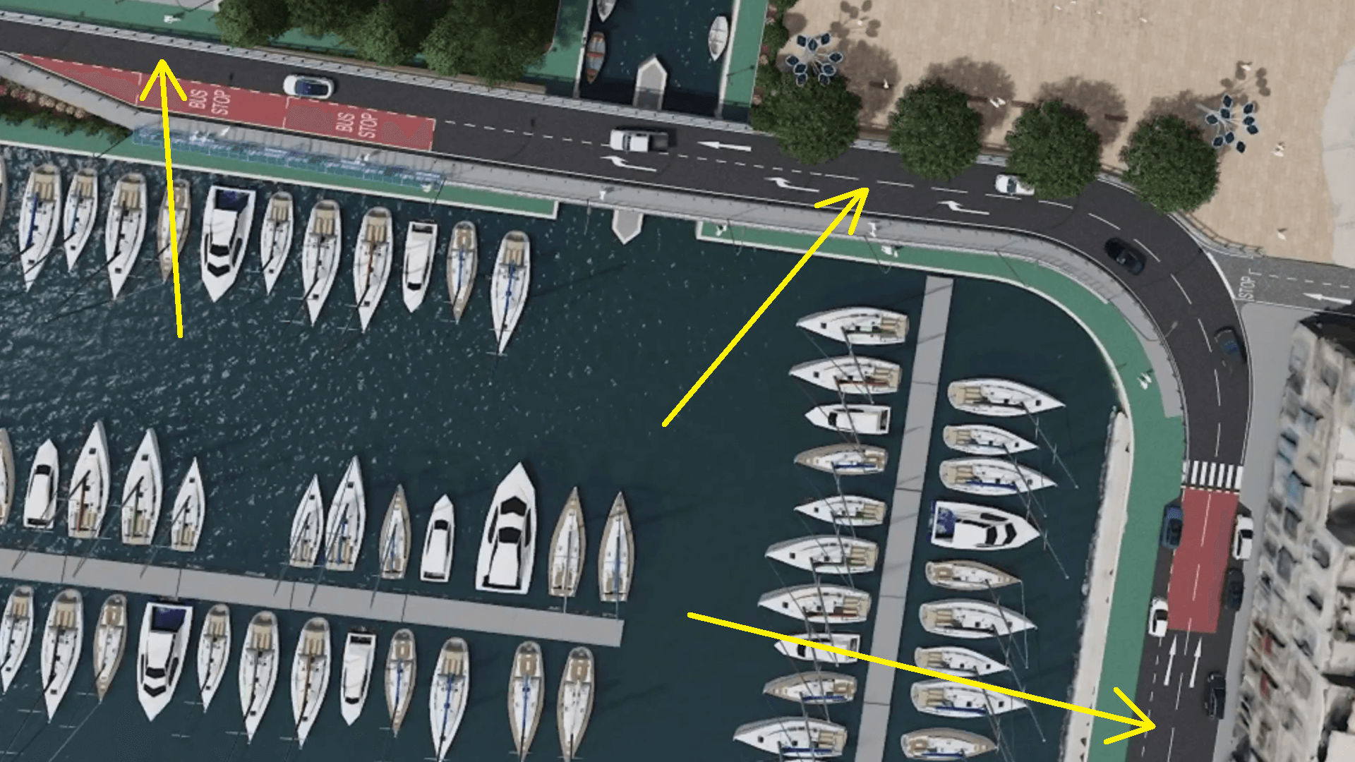
- Given the huge space of the junction (narrowest point being 70 metres wide) this can be easily achieved by shifting the entire car configuration more centrally to gain 3 metres on either side for the bike paths.
A few merging lanes can also be changed or removed. The road from Msida Creek to Valley Road continues to 1 lane per direction, but in actual fact the available public road width is around 30 metres wide from the Local Council until the Għajn tal-Ħasselin. On-street one-way bicycle lanes can continue here per direction to create a bicycle transition between the Msida Creek Project and Valley Road.
Connectivity from Ta’ Xbiex to Birkirkara
It is encouraging to see the car connection from Ta’ Xbiex to Birkirkara removed, as that means drivers will be more likely to opt for Regional Road well before-hand as it was originally intended for, and as a result reduce through-traffic in Ta’ Xbiex’s seafront. Connectivity for walking and cycling still remains rather rigid and problematic in this design, as there are a number of missing important links, especially to the University of Malta being an important hub for over 10,000 students, and the crossroads of all neighbouring towns.
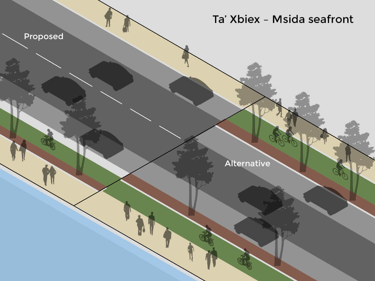
Therefore we suggest Triq ix-Xatt ta’ Ta’ Xbiex (Busy Bee, Mamma Mia, etc) to be transformed to a single lane road instead of two but keeping parking, to downgrade it to a local access road. It is already proposed to converge to 1 lane by the Kulleġġ bus stop now, so might as well start it earlier that way. This will gain space for a contraflow bicycle lane in the direction of Sliema, in tandem with the other bicycle lane being currently built by the GHRC promenades project in the direction of Pietà.
Rue d’Argens
Similarly, Rue d’Argens can afford to be kept to a single-lane (as it is today) instead of reinforced to another 2-lane road to Sliema, where bicycle lanes would be highly valuable here as well, given the presence of the nearby Kappara & Regional Road main roads connected by the main 4-lane hill of Skatepark.
Sa Maison / Pieta to Ta’ Xbiex Connection
Sa Maison/Pietà seafront to Ta’ Xbiex: While current pedestrian/bicycle levels coming from Sa Maison are currently low and could afford to mix together on the promenade as a shared path for the time being, we need to envisage a future uptake of walking and cycling from there as well, as it is the principal desirable road of the entire Msida/Sliema/St Julian’s peninsula to the capital city and to the north-south corridor of Marsa just 2km away. Keeping this as a four-lane road for the entire way blocks the potential for bus/bicycle lanes. A long-term plan should aim to shift through-traffic further out to the remainder of Regional Road by continuing to the Santa Venera tunnels, Marsa/Ħamrun bypass and Triq Diċembru 13.
Passageway between Kulleġġ bus stop (Junior College) and the Ġnien bus stop (church)
The passageway between the Kulleġġ bus stop (Junior College) and the Ġnien bus stop (church) seems to continue on a shared space of two-way pedestrian traffic and two-way bicycles/scooters, unsegregated from each other, in a space which looks quite small and gets narrower by the bus stop shelters. There is a high amount of pedestrian traffic in this area frequented by locals and students getting across the different bus stops.
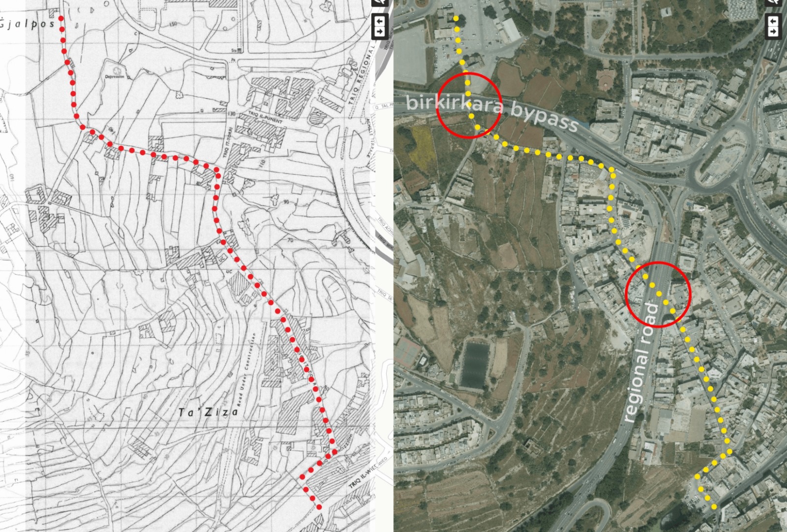
Road connecting Msida Creek to University of Malta
The main road between the Msida Creek and Skatepark junction has the space for bicycle lanes. The 4 lanes can still be retained but each lane needs to be slightly narrowed down, to match with its intended speed limit. The Skatepark roundabout at the top is a wider junction than the Msida Creek, spanning up at least 80 metres in diameter by 130m. The roundabout has ample room to fit in a Dutch-style roundabout connecting to University, Mater Dei Hospital & the valley tal-Għargħar to San Ġwann.
During Rota’s meeting with Infrastructure Malta, Rota welcomed the proposal by IM architects to open and connect the missing link of the existing Skatepark pedestrian underpass from the University to the villa areas of Ta’ Xmiexi.
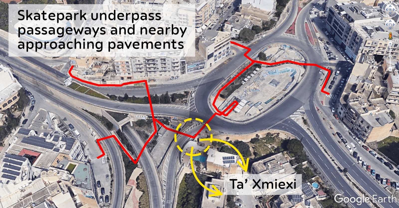 However, it should be noted that the winding underpass should be for secondary use, and reconnecting the older Triq it-Torri route should be the priority.
Concluding Remarks
While the proposed project is significantly improved over the previous design, it does not offer any substantial benefit for bicycle users over what currently exists in Msida. We still feel that this is a car-centric project that does not truly consider the needs of bicycle users. Bicycle infrastructure should adhere to the 5 CROW principles which include: 1) cohesion, 2) directness, 3) safety, 4) comfort and 5) attractiveness.
With additional work, this project can be highly improved and serve as an important foundation for future infrastructural work to target active mobility in Malta. Such interventions can positively impact the lives of many, and will affect our environment and our mental and physical health. Additionally, these interventions will make our roads safer and lead to less accidents and deaths, which have reached record levels this year.
We hope our suggestions do not fall on deaf ears. It is much easier to affect such changes in the planning stage than in retrospect.